Meriden, CT / Wallingford, CT maps and illustrations showing historical company locations
An artdesigncafe / Design Meriden resource.
 |
 |
| Material status: |
= online = link to more info = completely offline |
A. Maps / illustrations of Meriden [1] (Wallingford in section B below)
| 1850s | 1851 - mapWoodford, E. M. (1851). Plan of the town of Meriden, New Haven County, Connecticut [with numerous markings of locations of 1856-era companies and pewterers / britannia makers]. Richard Clark: Philadelphia. (Viewed 3 October 2020. E01641). 1856 - map(1856). Map of New Haven County, Connecticut [with numerous markings of locations of 1856-era companies and pewterers / britannia makers]. H & C. T. Smith: Philadelphia. (Viewed 1 October 2020. E01632). |
| 1860s | 1868 - mapBeers, F. W. (1868). Plan of the city of Meriden, New Haven Co., Conn. from actual surveys map [with several manufacturers indicated]. Beers, Ellis & Soule: New York. (Viewed 3 October 2020. E01642). |
| 1870s | 1875 - bird’s eye view mapO. H. Bailey & Co. (1875). City of Meriden, Conn 1875: [birds eye view]. Boston. [1 print; lithograph, 55 x 67 cm]. [“View of Meriden Conn. with fifty-eight public buildings, churches, businesses and factories identified at foot. "The Bradley & Hubbard Manufacturing Co.," the "Meriden Fire Insurance Co." and "the Meriden Brittania [sic] Co." buildings are below the main image. (Viewed 24 July 2016. A00048; A01099). |
| 1880s | 1881 - illustrationPorter, Wils (lithographer). (1881). Meriden, Conn. 1881 / From Summit Heights. [print (lithograph)]. B. S. Farrow (Publisher). [Including illustrations of various companies.] (Object no. 1973.0498.004. Viewed 3 June 2017. A02584-85). 1884 - mapSanborn Map & Publishing Co. (1884). Meriden, Connecticut. 14 leaves. (Viewed 2 July 2016. A01026; AAA00008). |
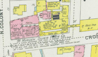
| 1890s | 1891 - mapSanborn-Perris Map Co. (1891). Meriden, Connecticut. 27 leaves. (Viewed 2 July 2016. A01025; AAA00007). 1891 - mapS. C. Pierson, Eng. (1891). Map of Meriden. 44 x 43 inches. (Viewed 21 November 2016. C00002-10).
1896 - mapSanborn-Perris Map Co. (1896). Insurance maps of Meriden, New Haven, Connecticut. 32 leaves. (Viewed 2 July 2016. A01024; AAA00006). |
| 1900s | 1901 - mapSanborn-Perris Map Co. (1901). Insurance maps of Meriden, New Haven, Connecticut. 49 leaves. (Viewed 2 July 2016. A01023; AAA00005). |
| 1910s | 1918 - aero view map(1918). Aero view of Meriden, Connecticut. [Including illustrations of various companies.] Hughes & Bailey: Boston. (Viewed 2 July 2016. A01020-21). 1919 - mapPrice & Lee Co. (1919). City of Meriden map. (Updated 13 May 2020. A01022; A01277; AAA00004; H01511). |
| 1920s | 1921 - map(1921). Insurance maps of Meriden, New Haven, Connecticut [New and additional sheets]. 2 leaves. (Viewed 21 November 2016. AAA00492). |
| 1930s | 1931 - map(1931). City of Meriden map. Unknown publisher. (Viewed 22 November 2016. A01278). |
B. Maps / illustrations of Wallingford
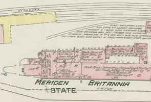
| 1880s | 1881 - bird’s eye view mapO. H. Bailey & Co. (1881). View of Wallingford, Connecticut. [Bird’s eye view illustration.] Boston, MA. (Illustrations include Hall, Elton & Co. [no. 20]; Judd’s Foundry [no. 21]; Oneida Community Limited [no. 18, and illustrated panel]; R. Wallace & Sons Mfg. Co. [no. 17, and illustrated panel]; Simpson, Hall [Miller & Co., no. 22]). (Viewed 2 October 2020. E01637-38). 1885 - mapSanborn Map & Publishing Co. (1885). Wallingford, Conn. map. 4 leaves. (Viewed 21 November 2016. AAA00486). |
| 1890s | 1892 - mapSanborn-Perris Map Co. (1892). Wallingford, New Haven Co., Conn. map. 6 leaves. (Viewed 21 November 2016. AAA00487). 1897 - mapSanborn-Perris Map Co. (1897). Wallingford, New Haven Co., Conn. map. 7 leaves. Viewed 21 November 2016. AAA00488). |
| 1900s | 1904 - mapSanborn Map Co. (1904). Wallingford, New Haven County, Conn. map. 9 leaves. (Viewed 21 November 2016. AAA00489). 1905 - map(1905). Bird’s eye view of Wallingford [including H. L. Judd Co. illustration and listing no. 35; "International Silver Co., Successor to Simpson, Hall, Miller & Co., Factory ’L’" illustration and listing no. 34; Simpson Nickel Silver Co., International Silver Co., Factory ’M’ illustration; and R. Wallace & Sons Mfg. Co. illustration and listing no. 56]. Hughes & Bailey. (Viewed 1 October 2020. E01633-34). |
| 1910s | 1911 - mapSanborn Map Co. (1911). Wallingford, New Haven County, Connecticut map. 16 leaves. (Viewed 21 November 2016. AAA00490). 1919 - mapSanborn Map Co. (1919). Wallingford, New Haven County, Connecticut map. 17 leaves. Viewed 21 November 2016. AAA00491). |
Footnote:
[1] For those unfamiliar with the street layouts in the Meriden area, with the site address, you can search the location on Google Maps, and then refer to the historical maps above.
DESIGN MERIDEN:
1: History books - Meriden / Wallingford / Middletown area | 2: Historical maps - Meriden / Wallingford area | 3: Exhibitions of historical Meriden-area art and design (1851-present)
This list is in development. If you know of other maps, 1830-1960, please contact artdesigncafe.